Advancing Bushfire Preparedness in Australia
Artificial intelligence (AI) is set to enhance Australia's bushfire response. We're excited to share the first bushfire imagery from the FireSat proto satellite, launched by Muon Space in March on behalf of the global nonprofit Earth Fire Alliance.
In Australia, AFAC (the Australian and New Zealand Council for fire and emergency services) and CSIRO, the national science agency, are collaborating with Earth Fire Alliance, and with support from Google.org and Google Australia, to help the nation prepare for FireSat data. Their aim: to improve how Australia detects, tracks, and responds to bushfires.
Bushfires are a growing concern, often hard to spot early. FireSat provides quick, detailed information, detecting fires as small as 5x5 metres. Once operational, it will speed up first responder actions and aid scientific understanding.
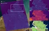
FireSat can detect multiple simultaneous wildfires across large landscapes to enable coordinated response efforts. Multiple active fires were detected near Borroloola, Northern Territory, Australia, on July 11, 2025. FireSat’s Mid-Wave Infrared (MWIR) channel identified a number of active fire areas and burning fire fronts scattered throughout the region. Both the MWIR and Long-Wave Infrared (LWIR) channels reveal variations in surface temperatures across the landscape, providing environmental context alongside precise fire detection.
Credit: Muon Space and Earth Fire Alliance.
Google.org funds AFAC’s Oceania Emerging Technologies Hub for global AI collaboration. Google Australia supports CSIRO’s Spark program, a bushfire simulation tool, that will use FireSat data and promote AI research on Google Cloud.
"AFAC is excited to be participating in this global project. Leveraging the strength of AFAC's established model of collaboration, we are delighted to be part of a global network of researchers and practitioners looking to integrate the best of satellite technologies, AI and emerging technologies with systems and processes,” said AFAC CEO Rob Webb.
Dr Mahesh Prakash from CSIRO added, "CSIRO has been at the forefront of wildfire science and associated model and product development for several decades now. We have been collaborating with AFAC, emergency management agencies and Google for the past few years to strengthen our ability to keep communities safe in Australia.
“Our involvement in this project will allow CSIRO's fire science and wildfire predictive tools such as Spark to be scaled up globally helping to build disaster resilience in communities at risk.”
This collaboration reflects Google’s commitment to helping emergency responders and advancing bushfire understanding in Australia.
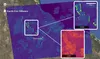
This FireSat image captures several fires across the Dampier region in Western Australia, demonstrating a broad-picture scope of concurrent fires. The Mid-Wave Infrared (MWIR) channel detects small, early-stage fires while the Long-Wave Infrared (LWIR) channel highlights a range of active fire temperatures. This image shows FireSat's ability to identify fires early, monitor ongoing fire conditions, and show end users the full range of active fires in their region to inform allocation of finite resources for response.
Credit: Muon Space and Earth Fire Alliance.